Category: History

歴史

  • Exploring Matsumae: Hokkaido’s Only Samurai Castle and Frontier Domain

    Exploring Matsumae: Hokkaido’s Only Samurai Castle and Frontier Domain

    Matsumae, located in Hokkaido Prefecture, is home to the northernmost samurai castle in Japan, Matsumae Castle. This historic site offers a glimpse into the unique history of the Matsumae Domain, the only feudal domain in Hokkaido during the Edo period.

    Flag with Crest of Kakizaki later Matsumae clan, Weltmuseum Wien, acquired by Heinrich von Siebold (1852–1908), perhaps on hi
    “Flag with crest of Kakizaki later Matsumae clan (Weltmuseum Wien)” by Unknown flag-maker, Public domain, via Wikimedia Commons

    Introduction to Matsumae: Hokkaido’s Historic Samurai Frontier

    FACT: The Matsumae Domain’s Unique Role

    The Matsumae Domain was the only feudal domain located in Hokkaido during the Edo period. Established to manage trade and relations with the indigenous Ainu people, the domain played a crucial role in the region’s development. Matsumae Castle, also known as Fukuyama Castle, served as the administrative center of this domain, overseeing the strategic and economic interests of the area. The castle’s location in Matsumae Town, overlooking the Tsugaru Strait, highlights its importance in maritime trade and defense.

    Watercolour scene of Matsumae Castle at sunrise, with soft colors and distant silhouettes in a misty landscape.
    AI生成イメージ / AI-generated illustration (not a photograph of the actual place)

    The Rise of the Matsumae Domain During the Edo Period

    FACT: Governance and Trade

    The Matsumae Domain was granted exclusive rights to trade with the Ainu, which was a significant aspect of its governance. This monopoly allowed the Matsumae clan to flourish economically and maintain control over Hokkaido’s southern regions. The domain’s policies and interactions with the Ainu were pivotal in shaping the cultural and economic landscape of the area. The strategic location of Matsumae Castle facilitated the control of trade routes and ensured the domain’s prosperity.

    FACT: The Economic Impact of Trade

    The economic impact of the Matsumae Domain’s trade monopoly was profound. By controlling the flow of goods between the Japanese mainland and Hokkaido, the Matsumae clan could exert significant influence over regional commerce. This control not only enriched the domain but also allowed for the cultural exchange between the Japanese and the Ainu, leading to a unique blend of traditions and practices in the region.

    Matsumae-Castle - Matsumae Castle Keep Tower
    “Matsumae-Castle” (Matsumae Castle Keep Tower) by MaedaAkihiko, CC0, source, via Wikimedia Commons

    Matsumae Castle: Japan’s Northernmost Feudal Fortress

    FACT: Architectural and Historical Significance

    Matsumae Castle, built in the early 17th century, stands as a testament to the strategic foresight of the Matsumae clan. As the northernmost feudal fortress in Japan, it was designed to withstand harsh weather and potential invasions. Today, visitors can explore the castle grounds and enjoy panoramic views of the surrounding landscape, offering a window into the past and the enduring legacy of the samurai era in Hokkaido. The castle’s architecture reflects the traditional Japanese style, with defensive features adapted to the northern climate.

    FACT: Preservation and Cultural Heritage

    The preservation of Matsumae Castle is a testament to its cultural and historical significance. Efforts to maintain the castle have ensured that it remains a key attraction for visitors interested in Japan’s feudal history. The castle’s museum offers insights into the life of the samurai and the history of the Matsumae Domain, providing a comprehensive understanding of the region’s past.

    Trade, Conflict, and Relations with the Ainu

    FACT: Interactions with the Ainu

    The Matsumae Domain’s interactions with the Ainu were complex and multifaceted. While trade was a primary focus, the relationship also involved cultural exchanges and occasional conflicts. The domain’s policies towards the Ainu were instrumental in the broader context of Japanese expansion into Hokkaido, influencing both the social and economic dynamics of the region. These interactions were marked by both cooperation and tension, reflecting the challenges of cultural integration and economic dependency.

    FACT: Cultural Exchange and Influence

    The cultural exchange between the Matsumae Domain and the Ainu led to a unique blend of traditions. The Ainu influenced local customs, cuisine, and crafts, contributing to the rich cultural tapestry of the region. This exchange was not without its challenges, as differing worldviews and economic interests sometimes led to conflict. However, the legacy of this interaction is evident in the cultural diversity that characterizes Matsumae today.

    松前城のさくら(Cherry blossom of the Matsumae Castle) - panoramio - Sakura in Hokkaido, Matsumae Castle Keep Tower
    “松前城のさくら(Cherry blossom of the Matsumae Castle) – panoramio” (Sakura in Hokkaido, Matsumae Castle Keep Tower) by pakku, CC BY 3.0, source, via Wikimedia Commons

    Savoring Local Flavor: The History of Matsumaezuke

    FACT: A Culinary Tradition

    Matsumaezuke, a local specialty of Matsumae, is a pickled delicacy made from squid, herring roe, and kelp. This dish has been a part of the region’s culinary heritage for over a hundred years, reflecting the area’s rich maritime resources and trade history. Visitors to Matsumae can sample this unique flavor, which embodies the fusion of local ingredients and traditional preservation methods. The pickling process enhances the natural flavors of the seafood, creating a dish that is both savory and umami-rich.

    FACT: Matsumaezuke’s Cultural Significance

    Matsumaezuke is more than just a dish; it is a symbol of the region’s history and its connection to the sea. The ingredients used in Matsumaezuke are sourced from the surrounding waters, highlighting the importance of the ocean to the local economy and culture. This culinary tradition is celebrated in local festivals and is a must-try for visitors seeking to experience the authentic taste of Matsumae.

    Planning Your Visit to Matsumae in Southern Hokkaido

    Check the official website for current hours, fees, and access to Matsumae Castle and other attractions in the area. The castle and surrounding sites offer a comprehensive look at the historical and cultural significance of the Matsumae Domain. Visitors are encouraged to explore the nearby Matsumae Park and the Matsumae Domain Residence to gain a deeper understanding of the region’s rich heritage.

    Nearby Guide

    Access

    • Matsushiro Bus Stop (Matsumae) — From Kikonai Station, take the Hakodate Bus Kikonai-Matsumae line to Matsushiro Bus Stop. The bus ride takes approximately 90 minutes. From the bus stop, Matsumae Castle is a 10-minute walk away. official site

    Nearby sights

    • Matsumae Park (Matsumae) — Adjacent to Matsumae Castle, Matsumae Park is renowned for its cherry blossoms, featuring approximately 10,000 trees of 250 varieties. The park also includes historic ruins and temples, offering a glimpse into the area’s rich past. official site
    • Matsumae Domain Residence (Matsumae) — Explore the former residence of the Matsumae clan, which offers insights into the lifestyle and history of the feudal lords who once governed the region. official site

    Where to stay

    • Hotel Kikunoya (Matsumae) — A comfortable hotel offering modern amenities and easy access to local attractions, including Matsumae Castle and Matsumae Park. official site

    Where to eat

    • Hokuyodo (Matsumae) — A local confectionery shop known for its ‘Oshiro Monaka,’ a sweet filled with red bean jam shaped like Matsumae Castle, and sakura-flavored sponge cakes. details
    Locator map of Japan: Matsumae, Hokkaido
    Legend site: Matsumae, Hokkaido — Source: Map of Japan with highlight on 01 Hokkaido prefecture.svg; Map: Lincun, CC BY-SA 3.0, via Wikimedia Commons

    Regional guide

    Location: Matsumae, Hokkaido Prefecture

    • Matsumaezuke (Matsumae) — source

    Sources

    About the author

    JAPAN ESSENCE Editorial Team
    Our mission is to bring you Japan’s legends, myths, festivals and living traditions, through both historical fact and the stories passed down over generations.

  • From Geological Birth to Meiji Pioneers: The Layered Timeline of Hokkaido and Sapporo

    From Geological Birth to Meiji Pioneers: The Layered Timeline of Hokkaido and Sapporo

    Hokkaido, Japan’s northernmost island, offers a rich tapestry of history that spans from its geological formation to its development during the Meiji era. In Sapporo, Hokkaido Prefecture, these layers of history are vividly illustrated through both natural formations and cultural landmarks.

    Ainu elder by a river in a Hokkaido landscape, symbolizing cultural connection.
    AI生成イメージ / AI-generated illustration (not a photograph of the actual place)

    Geological Birth: The Collision That Shaped Hokkaido and the Ishikari Plain

    FACT: Formation of Hokkaido’s Landscape

    The geological formation of Hokkaido dates back approximately 40 million years. This was a time when the Old Okhotsk Land and Old West Land collided, resulting in the uplift of the Hidaka mountain range and the creation of the Ishikari Plain. This monumental event laid the foundation for the diverse landscapes that characterize Hokkaido today.

    Visitors to Sapporo can appreciate the remnants of this ancient collision in the form of the surrounding mountains and plains. The Hidaka range, in particular, remains a testament to the island’s dynamic geological history, offering a stunning backdrop to the modern cityscape. Hiking trails and scenic viewpoints allow visitors to immerse themselves in the natural beauty that was sculpted by these ancient forces. The Ishikari Plain, meanwhile, is a fertile area that has supported agriculture and settlement for centuries, highlighting the enduring impact of these geological processes.

    Ancient Roots: Early Jomon Pottery and Indigenous Heritage

    FACT: Jomon Pottery in Hokkaido

    Approximately 13,000 years ago, pottery first appeared in Hokkaido at the Taisho 3 Site in Obihiro. This development coincided with the Incipient Jōmon period and was likely introduced by migrants from Honshu. The discovery of these ancient artifacts provides valuable insight into the early human history of the region and the cultural exchanges that took place across Japan.

    These early Jomon artifacts highlight the long-standing human presence in Hokkaido and the island’s role as a cultural crossroads. Museums in the region, such as the Hokkaido Digital Museum, offer exhibitions that delve into this rich prehistoric heritage. These exhibitions provide an opportunity to see the intricate designs and craftsmanship of Jomon pottery, reflecting the artistic and functional aspects of these ancient creations. The pottery’s distinctive patterns and forms reveal much about the daily lives, beliefs, and artistic expressions of the Jomon people, making it a fascinating subject for both historians and casual visitors alike.

    Sapporo Concert Hall Kitara-20091013-RM-122400 - Sapporo Concert Hall Kitara
    “Sapporo Concert Hall Kitara-20091013-RM-122400” (Sapporo Concert Hall Kitara) by Ermell, CC BY-SA 4.0, source, via Wikimedia Commons

    Etymology and Meaning: The Ainu Origins of the Name ‘Sapporo’

    LEGEND: The Ainu Connection

    According to local tradition, the name ‘Sapporo’ is derived from the Ainu language, reflecting the deep-rooted connection between the indigenous Ainu people and the land. The Ainu, who have lived in Hokkaido for centuries, have a rich cultural heritage that is intertwined with the island’s history.

    While the exact etymology of ‘Sapporo’ remains a subject of debate, it is widely believed that the name is linked to the Ainu words for ‘dry, great river’ or ‘important river flowing through a plain.’ This interpretation underscores the significance of the region’s waterways in the lives of its early inhabitants. Visitors can explore Ainu culture further through local cultural centers and events that celebrate and preserve their traditions. These centers offer insights into the Ainu’s unique language, crafts, and ceremonies, providing a deeper understanding of their enduring legacy in Hokkaido.

    Pioneering the North: The Kaitakushi and Meiji Modernization

    FACT: Establishment of the Hokkaido Development Commission

    In 1869, the Meiji government established the Hokkaido Development Commission, known as the Kaitakushi, to spearhead the development of Hokkaido. This initiative marked a pivotal moment in the island’s history, as it transitioned from a remote frontier to a key area of modernization and settlement.

    The Kaitakushi’s efforts included the founding of Sapporo Agricultural College in 1876, which played a crucial role in introducing Western agricultural practices to Japan. This period of rapid development laid the groundwork for Sapporo’s emergence as a major urban center. Visitors interested in this transformative era can explore historical sites and museums that showcase the innovations and challenges of the time. The legacy of the Kaitakushi is evident in the city’s layout and infrastructure, which reflect the ambitious vision of its founders to create a thriving hub of industry and culture.

    Sapporo Mt.Moiwa Shinto shrine-20091012-RM-130629 - Torii in Sapporo
    “Sapporo Mt.Moiwa Shinto shrine-20091012-RM-130629” (Torii in Sapporo) by Ermell, CC BY-SA 4.0, source, via Wikimedia Commons

    Icons of Growth: William S. Clark and the Red Brick Office Building

    FACT: The Red Brick Office Building

    The Red Brick Office Building, completed in 1888, stands as a symbol of Sapporo’s Meiji-era growth. Built on the site of the Kaitakushi headquarters, this Neo-Baroque structure is designated as a National Important Cultural Property and National Historic Site. It serves as a vivid reminder of the city’s transformation during this transformative period.

    Visitors can explore the Former Hokkaido Government Office Building, often referred to as the ‘Red Brick Office,’ to learn more about the region’s development and the architectural legacy of the Meiji era. The building is conveniently located in Chūō-ku, Sapporo, and is accessible from JR Sapporo Station. Exhibits within the building offer insights into the political and economic strategies that shaped modern Hokkaido. The architecture itself, with its grand design and historical significance, provides a tangible connection to the past, inviting visitors to reflect on the ambitious spirit of the Meiji period.

    Visiting Sapporo’s Historic Sites Today

    Today, Sapporo offers a wealth of historical sites that reflect its layered past. From the geological wonders of the Hidaka mountains to the cultural landmarks of the Meiji era, the city invites visitors to explore its rich history. Walking tours and guided visits provide an immersive experience, allowing one to step back in time and witness the evolution of this vibrant region. These tours often include storytelling elements that bring the history to life, making the exploration both educational and engaging.

    Nearby Guide

    Access

    • JR Sapporo Station (Sapporo) — Approximately 8 minutes on foot from the South Exit on the west side of JR Sapporo Station. official site
    • Sapporo Station Subway Exit 10 (Sapporo) — Approximately 4 minutes on foot from Exit No. 10 of Sapporo Station on the Namboku and Toho subway lines. official site
    • Odori Station Subway Exit 2 (Sapporo) — Approximately 9 minutes on foot from Exit No. 2 of Odori Station on the Namboku, Tohoku, and Toho subway lines. official site

    Where to stay

    • Hotel Keihan Sapporo (Sapporo) — A modern hotel located near Sapporo Station, offering comfortable accommodations and easy access to major attractions, including the Former Hokkaido Government Office Building. official site
    Locator map of Japan: Sapporo, Hokkaido
    Legend site: Sapporo, Hokkaido — Source: Map of Japan with highlight on 01 Hokkaido prefecture.svg; Map: Lincun, CC BY-SA 3.0, via Wikimedia Commons

    Regional guide

    Location: Sapporo, Hokkaido Prefecture

    • Former Hokkaido Government Office Building (‘Red Brick Office’) (Sapporo) — source

    Sources

    About the author

    JAPAN ESSENCE Editorial Team
    Our mission is to bring you Japan’s legends, myths, festivals and living traditions, through both historical fact and the stories passed down over generations.

  • Koshamain’s War: Exploring Hokkaido’s Medieval History in Kaminokuni

    Koshamain’s War: Exploring Hokkaido’s Medieval History in Kaminokuni

    On the Oshima Peninsula in Hokkaido, the town of Kaminokuni holds the echoes of a pivotal moment in Japanese history: Koshamain’s War. This conflict between the indigenous Ainu people and the mainland Wajin settlers in 1457 left a lasting imprint on the region, with remnants of medieval fortifications still visible today.

    Medieval Hokkaido landscape with autumn trees, distant figures near ruins, under a vivid blue sky.
    AI生成イメージ / AI-generated illustration (not a photograph of the actual place)

    Introduction to Koshamain’s War and Southern Hokkaido

    FACT: The Historical Context of Koshamain’s War

    Koshamain’s War was a significant conflict that took place in 1457 on the Oshima Peninsula, particularly affecting the area around Kaminokuni in Hokkaido. This war was a result of escalating tensions between the indigenous Ainu people and the Wajin settlers from mainland Japan. The conflict is named after Koshamain, an Ainu leader who led the resistance against the Wajin encroachment. The Ainu were the indigenous people of Hokkaido, with a distinct culture and language, while the Wajin were settlers from the Japanese mainland who began to establish a presence in Hokkaido during the medieval period. This clash of cultures and interests laid the groundwork for the conflict that would become known as Koshamain’s War.

    The 1456 Knife Dispute: How the Conflict Began

    FACT: The Incident That Sparked the War

    According to the historical records of Kaminokuni, the conflict was ignited in 1456 by an incident in Shinori, near present-day Hakodate. An Ainu boy refused to pay for a makiri, a traditional knife, and taunted the Wajin smith. In a fit of anger, the smith killed the boy, an act that sparked outrage among the Ainu and led to the first large-scale conflict between the Ainu and Wajin. The makiri was not just a utilitarian tool but also held cultural significance, often intricately carved and used in daily life by the Ainu. The incident underscored the cultural misunderstandings and economic tensions between the two groups, setting off a chain of events that would escalate into full-scale war.

    Kaminokuni Katuyamadate - Katsuyama-date
    “Kaminokuni Katuyamadate” (Katsuyama-date) by On-neko, CC BY-SA 4.0, source, via Wikimedia Commons

    The Course of the 1457–1458 Conflict and Takeda Nobuhiro

    FACT: The Role of Takeda Nobuhiro

    During the conflict, Takeda Nobuhiro, a prominent Wajin figure, played a crucial role in defending against the Ainu uprising. Nobuhiro’s strategic acumen and military prowess were instrumental in the Wajin’s eventual victory, which further solidified their presence in the region. The war ended with the defeat of Koshamain and the Ainu forces, leading to a period of increased Wajin settlement and influence in Hokkaido. Nobuhiro’s leadership not only helped to quell the uprising but also paved the way for the expansion of Wajin influence in the area, marking a significant shift in the region’s demographic and cultural landscape.

    Exploring Medieval Wajin Fortified Residences in Kaminokuni

    FACT: The Fortified Residences of Kaminokuni

    In Kaminokuni, visitors can explore the remnants of three medieval Wajin fortified residences: Hanazawa-date, Suzaki-date, and Katsuyama-date. These earthwork fortifications were built by the Wajin settlers during the fifteenth century as a defense against the Ainu. The sites are located on a grassy ridge, offering a glimpse into the strategic military architecture of the time. These fortifications, known as “date,” were constructed using earthworks and wooden structures, strategically positioned to take advantage of the natural terrain. They served as both military strongholds and symbols of Wajin authority in the region.

    FACT: Visiting the Fortified Residences

    Visitors to Kaminokuni can walk among these historical ruins, which provide a tangible connection to the past. The earthworks, though weathered by time, still outline the defensive structures that once stood. Interpretive signs and pathways guide visitors through the sites, offering insights into the historical significance and construction techniques of these fortifications. The location on a ridge not only provided a strategic vantage point but also offers breathtaking views of the surrounding landscape, allowing visitors to appreciate the natural beauty that played a role in the site’s selection.

    Koanzai, Kaminokuni, Hiyama District, Hokkaido Prefecture 049-0605, Japan - panoramio - Kaminokuni, Hokkaido
    “Koanzai, Kaminokuni, Hiyama District, Hokkaido Prefecture 049-0605, Japan – panoramio” (Kaminokuni, Hokkaido) by hiroaki kenchi, CC BY 3.0, source, via Wikimedia Commons

    Mount Io and Modern Commemoration of the Conflict

    FACT: Memorials and Modern Remembrance

    Mount Io in Kaminokuni serves as a memorial site for the events of Koshamain’s War. The area offers panoramic views of the Sea of Japan and Okushiri Island, providing a serene backdrop for reflection on this historical conflict. The memorials and fort ruins in Kaminokuni are part of the region’s cultural heritage, attracting history enthusiasts and tourists alike. The memorial site at Mount Io is a place where visitors can contemplate the impact of the war and the resilience of the people who lived through it. The site is marked by commemorative plaques and monuments that honor the memory of those who fought and died in the conflict.

    How to Visit the Historical Sites in Kaminokuni

    Visitors interested in exploring the historical sites related to Koshamain’s War can access Kaminokuni by car from Hakodate, approximately a 1.5-hour drive along National Route 228. Public transportation options are limited, so renting a car is recommended for flexibility and convenience. Check the official website for current hours, fees, and access information. The journey to Kaminokuni offers a scenic drive through the Hokkaido countryside, with opportunities to stop and enjoy the natural beauty of the region along the way.

    Nearby Guide

    Access

    • Kaminokuni Town (Kaminokuni) — Kaminokuni is accessible by car from Hakodate, approximately a 1.5-hour drive along National Route 228. Public transportation options are limited, so renting a car is recommended for flexibility and convenience. official site

    Nearby sights

    • Katsuyama-date Ruins (Kaminokuni) — Katsuyama-date is a 15th-century fortified settlement located on the hillside of Mount Iō. The site features reconstructed wooden palisades, dry moats, and bridges, with explanatory boards along the paths. The Katsuyama Castle Guidance Facility at the foot of the slope offers a 1:200 model of the fort. official site
    • Former Sasanami Family Residence (Kaminokuni) — The Former Sasanami Residence is one of the oldest surviving houses in Hokkaido, built in the early 19th century by a herring-family. The residence is open from April 11 to November 8, with hours from 10:00 to 16:00 and closures on Mondays. Admission is 300 yen for adults and 100 yen for students. official site
    • Mount Iō (Iōzan) (Kaminokuni) — Mount Iō, also known as Iōzan, is a 159-meter-high summit offering panoramic views of the coastline of the Sea of Japan and Okushiri Island. The top can be reached in approximately three minutes from the nearest parking lot. The area is accessible by car from Kikonai Station, about a 40-minute drive. details

    Where to stay

    • Kaminokuni Monju Roadside Station (Kaminokuni) — Kaminokuni Monju Roadside Station offers local produce and seafood inside, and a lookout that fills up at sunset. The facility also houses a restaurant with a sweeping view of the Japan Sea. Located at Aza Harauta 3 Banchi, Kaminokuni-cho, Hiyama-Gun, Hokkaido. The shop is open 9:00–17:00 from April to October and 10:00–17:00 from November to March; the restaurant is open 11:00–15:00 (last orders 14:30). The shop and restaurant close on Mondays from November to March (the next weekday if Monday is a public holiday). The facility closes December 31–January 5; temporary closures or shorter hours may apply. Check the official operating information before visiting. official site

    Where to eat

    • Tekkui Tempura Donburi (Kaminokuni) — A popular dish at the Kaminokuni Monju Roadside Station, Tekkui Tempura Donburi features local seafood tempura served over rice. The roadside station also offers a delicious smoothie made with Kaminokuni strawberries. official site
    Locator map of Japan: Kaminokuni, Hokkaido
    Legend site: Kaminokuni, Hokkaido — Source: Map of Japan with highlight on 01 Hokkaido prefecture.svg; Map: Lincun, CC BY-SA 3.0, via Wikimedia Commons

    Sources

    About the author

    JAPAN ESSENCE Editorial Team
    Our mission is to bring you Japan’s legends, myths, festivals and living traditions, through both historical fact and the stories passed down over generations.

  • Dazaifu-Style Onigawara: Ancient Kyushu’s Fierce Architectural Guardians

    Dazaifu-Style Onigawara: Ancient Kyushu’s Fierce Architectural Guardians

    In Dazaifu, Fukuoka Prefecture, the ancient art of onigawara—demon-faced roof tiles—reveals a fascinating glimpse into Japan’s architectural past. An onigawara excavated at the Dazaifu Government Office site is held by the Kyushu National Museum; see the dated exhibition information below before planning a visit.

    Watercolour of a fierce demon in Dazaifu landscape with cherry trees.
    AI生成イメージ / AI-generated illustration (not a photograph of the actual place)

    Introduction to Dazaifu-Style Onigawara

    FACT: What the records say

    The Dazaifu-style onigawara are distinguished by their high-relief demon faces, a stylistic hallmark of the region. These tiles are believed to have adorned the Dazaifu Government Office during the Nara period, serving both decorative and protective purposes. The site, known as Tofurō (都府楼), was a significant administrative center in ancient Kyushu, reflecting the region’s importance in Japan’s early governance.

    These tiles are not merely decorative; they are imbued with cultural and spiritual significance. The fierce expressions of the demon faces were thought to ward off evil spirits, a common belief in ancient Japan where architecture often incorporated spiritual elements to protect inhabitants. The onigawara’s presence at such a pivotal site underscores their role not just as architectural elements but as cultural symbols of protection and power.

    The Historic Role of Ancient Dazaifu

    FACT: A center of power and culture

    Dazaifu was more than just an administrative hub; it was a cultural and political powerhouse. Established as the regional government office, it played a crucial role in managing the affairs of Kyushu. The presence of onigawara at this site underscores the significance of these tiles as symbols of protection, warding off evil spirits and ensuring the safety of the building’s occupants.

    The government office in Dazaifu was a key location for the administration of the region, overseeing political, economic, and cultural matters. This made it a focal point for the dissemination of cultural practices and architectural styles, including the distinctive onigawara. The site served as a meeting point for various cultural influences, which is reflected in the unique design of the onigawara found there, blending both local and broader Japanese traditions.

    View from Former Dazaifu Headquarters - Dazaifu (government)
    “View from Former Dazaifu Headquarters” (Dazaifu (government)) by そらみみ, CC BY-SA 4.0, source, via Wikimedia Commons

    Distinctive Design and Symbolism of Kyushu’s Demon Tiles

    FACT: Artistic expression and cultural significance

    The onigawara from Dazaifu are noted for their intricate designs, which depict fierce demon faces intended to scare away malevolent forces. This artistic expression is not only a testament to the craftsmanship of the era but also reflects the cultural beliefs of ancient Japan, where such symbols were integral to architectural design.

    Craftsmen of the time skillfully shaped these tiles from clay, infusing them with both artistic flair and spiritual purpose. The demon faces, with their exaggerated features and intense expressions, embody the dual role of art and protection. The artistry involved in creating these tiles was a reflection of the high level of skill and the deep cultural significance attributed to these architectural elements.

    Comparing Dazaifu Style with Central Ancient Capitals

    FACT: Regional variations in onigawara

    While onigawara can be found throughout Japan, the Dazaifu style is particularly noted for its bold and aggressive features compared to those from central ancient capitals like Nara and Kyoto. This regional variation highlights the unique cultural influences and artistic preferences that shaped the architectural landscape of Kyushu.

    In contrast to the more refined and subdued styles seen in Nara and Kyoto, the Dazaifu onigawara are characterized by their pronounced features and dynamic expressions. This reflects a local adaptation of a broader Japanese tradition, emphasizing the region’s distinct cultural identity. The differences in style also suggest a regional interpretation of the spiritual and protective roles these tiles played, tailored to the specific cultural and environmental context of Kyushu.

    Stele of Former Dazaifu Headquarters - Dazaifu (government)
    “Stele of Former Dazaifu Headquarters” (Dazaifu (government)) by そらみみ, CC BY-SA 4.0, source, via Wikimedia Commons

    Where to See Authentic Onigawara in Fukuoka

    FACT: A documented tile at the Kyushu National Museum

    The museum’s official collection database records one Important Cultural Property onigawara (YJ20), excavated at the Tofurō site in Dazaifu, dating to the eighth century in the Nara period. Official collection record.

    As checked on October 24, 2026, the museum lists this tile as on display in the fourth-floor Cultural Exchange Exhibition’s Basic Exhibition Room, with a scheduled exhibition period of October 6, 2026 to April 11, 2027. Exhibition arrangements may change; check the official exhibition list before visiting. This is a dated schedule, not a promise of permanent display.

    Exploring the Dazaifu Government Office Ruins and Exhibition Hall

    FACT: Visiting the historical site

    The Site of the Dazaifu Government Office, where these onigawara once adorned the rooftops, is an essential destination for history enthusiasts. Although the original structures no longer stand, the site offers a glimpse into the past through its preserved ruins and informative displays. Check the official website for current hours, fees, and access.

    Walking through the ruins, visitors can imagine the grandeur of the ancient government office, with its protective onigawara watching over the complex. The site serves as a tangible connection to Japan’s historical narrative, inviting reflection on the interplay between architecture and cultural beliefs. The remnants of the site, along with the educational displays, provide a vivid picture of the administrative and cultural significance of Dazaifu in ancient Japan.

    Nearby Guide

    Access

    • Dazaifu Station (Dazaifu) — From Dazaifu Station, it’s a 30-minute walk to the Dazaifu Government Office Ruins. Alternatively, buses run from the station, taking just five minutes. official site
    • Tofuro-mae Station (Dazaifu) — From Tofuro-mae Station on the Nishitetsu Tenjin Omuta Line, it’s approximately a 15-minute walk to the Dazaifu Government Office Ruins. details

    Nearby sights

    • Kanzeonji Temple (Dazaifu) — A 15-minute walk from the Dazaifu Government Office Ruins, Kanzeonji Temple is the former center of Buddhism in Kyushu. details
    • Dazaifu Tenmangu Shrine (Dazaifu) — A 30-minute walk from the Dazaifu Government Office Ruins, Dazaifu Tenmangu Shrine is dedicated to the spirit of scholar Sugawara Michizane. details
    • Kyushu National Museum (Dazaifu) — A 35-minute walk from the Dazaifu Government Office Ruins, the Kyushu National Museum offers rich historical exhibits. official site

    Where to stay

    • Hotel New Gaea Dazaifu (Dazaifu) — A hotel offering comfortable accommodations in Dazaifu. details
    • Hotel Route-Inn Dazaifu (Dazaifu) — A hotel providing convenient lodging options in Dazaifu. details

    Where to eat

    • Uomura (Dazaifu) — A restaurant known for its fresh seafood dishes. details
    • Kibi Dazaifu (Dazaifu) — A shop offering local specialties and souvenirs. details
    Locator map of Japan: Dazaifu, Fukuoka
    Legend site: Dazaifu, Fukuoka — Source: Map of Japan with highlight on 40 Fukuoka prefecture.svg; Map: Lincun, CC BY-SA 3.0, via Wikimedia Commons

    Sources

    About the author

    JAPAN ESSENCE Editorial Team
    Our mission is to bring you Japan’s legends, myths, festivals and living traditions, through both historical fact and the stories passed down over generations.

  • Susenoja Cave Toyohashi: Unveiling History and Legend

    Susenoja Cave Toyohashi: Unveiling History and Legend

    In Toyohashi, Aichi Prefecture, lies Susenoja Cave, a site that intertwines the rich history of the Jōmon period with captivating local legends. Designated a National Historic Site of Japan, this limestone cave offers a glimpse into ancient life and folklore that continues to intrigue visitors.

    Giant serpent at Susenoja Cave entrance under golden sunlight.
    AI生成イメージ / AI-generated illustration (not a photograph of the actual place)

    Introduction to Susenoja Cave: Toyohashi’s Hidden Historical Site

    FACT: National Historic Site Designation

    Susenoja Cave, located in the Susecho neighborhood of Toyohashi, was designated a National Historic Site of Japan in 1957. This recognition highlights its significance as an archaeological treasure, providing insights into early human habitation during the Jōmon period. The designation not only preserves the cave but also underscores its cultural and historical value, ensuring that future generations can learn about and appreciate this ancient site.

    The designation as a National Historic Site means that Susenoja Cave is protected under Japanese law, which helps maintain its condition and prevents unauthorized alterations. This status also facilitates archaeological research, allowing experts to continue studying the artifacts and features of the cave to uncover more about the Jōmon period.

    Physical Layout and Exploring the Limestone Cave

    FACT: Archaeological Significance

    The cave is a limestone formation that served as a dwelling for people during the Jōmon period, approximately 14,000 to 300 BCE. Archaeological excavations have revealed various artifacts, indicating the cave’s role as a shelter and a site of human activity thousands of years ago. The limestone environment has helped preserve these artifacts, providing valuable information on the tools, pottery, and other items used by the Jōmon people.

    Visitors to Susenoja Cave can observe the natural limestone formations and imagine how the Jōmon people might have utilized the space for shelter and daily activities. The cave’s location on a hillside also offers a strategic vantage point, which may have been beneficial for the inhabitants in terms of defense and resource management.

    Susejaana - Susejaana
    “Susejaana” (Susejaana) by Alpsdake, CC BY-SA 4.0, source, via Wikimedia Commons

    Archaeological Discoveries: Jōmon Period Life in Aichi

    FACT: Evidence of Jōmon Habitation

    Artifacts found within Susenoja Cave include pottery and tools that suggest a thriving community once inhabited the area. These findings provide a window into the daily lives of the Jōmon people, showcasing their craftsmanship and adaptation to the environment. The pottery discovered at the site is particularly noteworthy, as it reflects the artistic and functional skills of the Jōmon culture.

    The tools unearthed at Susenoja Cave reveal the technological advancements of the Jōmon people, who were adept at creating implements for hunting, gathering, and other daily tasks. These artifacts not only highlight the ingenuity of the Jōmon society but also offer clues about their social structure and interactions with the surrounding environment.

    The Legend of the Underground Tunnel to Zenkō-ji

    LEGEND: Tunnel to Zenkō-ji

    According to local legend, Susenoja Cave once extended via an underground tunnel all the way to Zenkō-ji, a famous Buddhist temple in Nagano Prefecture. This tale has captured the imagination of many, though no physical evidence of such a tunnel has ever been found. The legend persists as a testament to the rich oral traditions of the region, illustrating how stories can enhance the mystique of historical sites.

    The idea of a tunnel connecting the cave to a distant temple like Zenkō-ji speaks to the human fascination with hidden pathways and secret connections. While the tale remains unproven, it adds an element of intrigue to Susenoja Cave, encouraging visitors to ponder the mysteries that may lie beneath the surface.

    Susejaana s3 - Susejaana
    “Susejaana s3” (Susejaana) by Alpsdake, CC BY-SA 4.0, source, via Wikimedia Commons

    Serpents, Warriors, and Buried Treasure Lore

    LEGEND: Guardians of the Cave

    Another fascinating legend associated with Susenoja Cave involves tales of buried gold guarded by a giant snake or supernatural warriors. These stories add an air of mystery to the cave, drawing visitors intrigued by the possibility of hidden treasures and mythical guardians. The image of a giant snake or supernatural warriors protecting treasure evokes a sense of adventure and the unknown, elements that are often central to captivating folklore.

    These legends reflect the cultural imagination and the ways in which people have historically imbued natural sites with supernatural significance. The stories of guardians and treasure may also serve as metaphors for the cave’s historical and cultural wealth, emphasizing the value of preserving and exploring such sites.

    How to Visit Susenoja Cave in Toyohashi

    Susenoja Cave is located on a hillside in the Susecho neighborhood of Toyohashi. Visitors interested in exploring this historical and legendary site should check the official website for current hours, fees, and access information. The cave’s location offers not only a journey into the past but also a chance to enjoy the natural beauty of the surrounding area.

    Locator map of Japan: Toyohashi, Aichi
    Legend site: Toyohashi, Aichi — Source: Map of Japan with highlight on 23 Aichi prefecture.svg; Map: Lincun, CC BY-SA 3.0, via Wikimedia Commons

    Sources

    About the author

    JAPAN ESSENCE Editorial Team
    Our mission is to bring you Japan’s legends, myths, festivals and living traditions, through both historical fact and the stories passed down over generations.

  • Following Chosokabe Motochika’s Legacy in Anan, Tokushima

    Following Chosokabe Motochika’s Legacy in Anan, Tokushima

    In Anan, Tokushima Prefecture, the legacy of Chosokabe Motochika, a prominent warlord of the Sengoku period, still resonates at historic sites like Ushiki Castle Ruins, which tell the tale of his campaigns and influence in the region. Nearby, Byodoji Temple, the 22nd temple of the Shikoku Pilgrimage, makes a fitting addition to a visit.

    Illustration of Chosokabe Motochika's era in a snowy Tokushima landscape.
    AI生成イメージ / AI-generated illustration (not a photograph of the actual place)

    Introduction to Chosokabe Motochika’s Campaign in Awa Province

    FACT: What the records say

    Chosokabe Motochika, born in 1539, was the head of the Chosokabe clan and a significant figure during Japan’s Sengoku period. Known for his strategic prowess, Motochika harbored ambitions to unify Shikoku under his rule. His campaign in Awa Province, now part of Tokushima Prefecture, was a crucial part of his military endeavors. Motochika’s forces, celebrated for their discipline and innovative tactics, successfully seized control over various territories, including Anan. His leadership style and military strategies left an indelible mark on the region, influencing the course of its history.

    His campaigns were characterized by a combination of military might and strategic alliances. Motochika’s ability to adapt to different battle conditions and his keen understanding of the geopolitical landscape were instrumental in his successes. The legacy of his military strategies is still studied by historians and military enthusiasts, offering insights into the complexities of Sengoku-era warfare.

    Ushiki Castle Ruins Park: Strategic Stronghold in Anan

    FACT: The historical significance of Ushiki Castle

    Ushiki Castle, located in Anan, Tokushima, was a strategic stronghold during the Sengoku period. It played a pivotal role in Chosokabe Motochika’s military campaigns. The castle’s location was chosen for its strategic vantage point, allowing Motochika’s forces to monitor and control the surrounding areas effectively. Today, the castle’s ruins are preserved within Ushiki Castle Ruins Park, where visitors can explore the remnants of the fortifications and enjoy panoramic views of the surrounding landscape. This site offers a tangible glimpse into the military strategies employed by Motochika and his forces, providing visitors with a deeper understanding of the historical context of the area.

    The castle’s design reflects the military architecture of the time, with features that would have been used to defend against sieges and invasions. Visitors can imagine the bustling activity that once took place within its walls, as soldiers prepared for battle and strategists planned their next moves. The park offers educational plaques and guided tours that enrich the visitor experience, making it a valuable educational resource.

    FACT: Visiting Ushiki Castle Ruins Park

    Visitors to Ushiki Castle Ruins Park can immerse themselves in the history of the Sengoku period while enjoying the natural beauty of the area. The park is accessible to the public, and visitors are encouraged to explore the site at their own pace. The panoramic views from the ruins offer a unique perspective on the strategic importance of the location, making it a must-visit for history enthusiasts and those interested in Japan’s feudal past.

    Information boards throughout the park provide context and historical background, enhancing the self-guided tour experience. The serene environment of the park, combined with its historical significance, makes it an ideal spot for reflection and appreciation of Japan’s rich cultural heritage.

    Byodoji-temple front - Outside stairs in Tokushima prefecture, Niō-mon, Byōdō-ji (Anan)
    “Byodoji-temple front” (Outside stairs in Tokushima prefecture, Niō-mon, Byōdō-ji (Anan)) by AreaPhoto, CC BY-SA 4.0, source, via Wikimedia Commons

    Byodoji Temple: Temple 22 of the Shikoku Pilgrimage

    FACT: Byodoji Temple’s place in history

    Byodoji Temple, located in Anan, Tokushima, is the 22nd temple on the Shikoku Pilgrimage route. According to the Shikoku 88 Temple Pilgrimage association, temple tradition holds that Kobo Daishi founded it in 814 after a milky-white spring welled up from a well he dug, which gave the temple its mountain name, Hakusuizan (“White Water Mountain”). The temple declined by the early Edo period and was revived in 1680. Today, Byodoji Temple remains a place of spiritual significance and historical interest, attracting pilgrims and history enthusiasts alike. The temple’s serene environment and historical architecture provide a peaceful retreat for visitors seeking to connect with the past.

    The present main hall was rebuilt in 1737 and the Daishi Hall was built in 1824. Inside the main hall are three box carts (hakoguruma) offered in the Taisho and Showa eras by pilgrims who, according to the temple, recovered the use of their legs here. The temple continues to be an active site of worship, blending historical reverence with contemporary religious practices.

    FACT: Exploring Byodoji Temple

    Visitors to Byodoji Temple can explore its historic grounds and appreciate the temple’s role in the region’s history. As part of the Shikoku Pilgrimage, the temple is a popular destination for those seeking spiritual fulfillment and a deeper understanding of Japan’s religious heritage. The temple’s architecture and tranquil surroundings offer a unique opportunity to reflect on the historical events that shaped the area.

    The temple hosts various events and ceremonies throughout the year, allowing visitors to experience traditional Japanese religious practices firsthand. These events provide an opportunity to engage with the local community and learn about the cultural traditions that have been passed down through generations.

    Separate Side Trip to Naruto: Ushihiko Shrine (宇志比古神社)

    FACT: Ushihiko Shrine is in Naruto, not Anan

    Ushihiko Shrine (宇志比古神社) is located in Ōasa-chō Ōtani, Naruto City, in northern Tokushima — not in Anan — so plan it as a separate trip rather than part of an Anan itinerary. According to Naruto City, the shrine was called Hachimangū in the Edo period and took the name Ushihiko Shrine in the Meiji era. Ridge tags (munafuda) show that its main hall was built in 1599 and repaired in 1635 and 1704, making it the oldest shrine building in Tokushima Prefecture with a clearly dated construction. The main hall was designated a national Important Cultural Property in 2000.

    If you combine it with other Naruto sights, Ryozenji, Temple 1 of the Shikoku Pilgrimage, is also in Naruto; according to the Shikoku 88 Temple Pilgrimage association, its halls were burned in 1582 by the forces of Chosokabe Motochika and later rebuilt.

    Byodoji-temple hondo - Main Hall, Byōdō-ji (Anan)
    “Byodoji-temple hondo” (Main Hall, Byōdō-ji (Anan)) by AreaPhoto, CC BY-SA 4.0, source, via Wikimedia Commons

    Planning Your Historical Journey Through Anan City

    For those planning to explore the historical sites in Anan, Tokushima, it is advisable to check the official websites for current hours, fees, and access information. These sites not only offer a journey through history but also provide a chance to experience the natural beauty and cultural heritage of the region. Visitors are encouraged to take their time exploring each site, allowing for a deeper appreciation of the area’s rich historical tapestry.

    The combination of historical exploration and natural beauty makes Anan City an ideal destination for those interested in Japan’s past. The city’s commitment to preserving its historical sites ensures that visitors can experience the legacy of Chosokabe Motochika and the cultural richness of Tokushima Prefecture.

    Nearby Guide

    Nearby sights

    • Kamoda Cape (Anan) — Kamoda Cape is the easternmost point of Shikoku, offering breathtaking views of the Pacific Ocean. It’s renowned for its unique sunrise phenomenon, where the sun appears as a ‘Daruma Asahi’ (Daruma sunrise) between late fall and winter. By public transport, take the Tokushima Bus bound for Anan Tsubakidomari from JR Anan Station to the Yokoo stop, then walk about 90 minutes; the tourism site lists about 30 minutes by car. official site
    Locator map of Japan: Anan, Tokushima
    Legend site: Anan, Tokushima — Source: Map of Japan with highlight on 36 Tokushima prefecture.svg; Map: Lincun, CC BY-SA 3.0, via Wikimedia Commons

    Sources

    About the author

    JAPAN ESSENCE Editorial Team
    Our mission is to bring you Japan’s legends, myths, festivals and living traditions, through both historical fact and the stories passed down over generations.

  • Exploring the Kawaratsuka Kiln Ruins: Ibaraki’s Ancient Tile Heritage

    Exploring the Kawaratsuka Kiln Ruins: Ibaraki’s Ancient Tile Heritage

    In Ishioka, Ibaraki Prefecture, lies a remarkable archaeological site that offers a glimpse into Japan’s ancient tile-making heritage. The Kawaratsuka Kiln ruins, designated a National Historic Site, are a testament to the region’s historical significance in the production of roof tiles and Sue ware.

    Kawaratsuka Pottery Kiln ruins in Ishioka, Ibaraki Prefecture, Japan
    “Kawaratsuka kiln ruins” by MChew, CC BY-SA 4.0, via Wikimedia Commons

    Introduction to the Kawaratsuka Kiln Ruins

    FACT: What the records say

    The Kawaratsuka Kiln ruins are situated in Ishioka City, Ibaraki Prefecture. This archaeological site, recognized as a National Historic Site in 2017, encompasses 35 kilns that date back to the 7th through the early 10th centuries AD. The site is a significant cultural asset, illustrating the evolution of kiln technology and ceramic production in the region.

    The designation as a National Historic Site underscores the importance of preserving this location as a cultural and historical resource. It provides insight into the technological advancements of the time and the role these kilns played in the broader context of Japanese architecture and society. The kilns’ historical value is further emphasized by their ability to demonstrate the transition from simple ceramic production to more complex architectural applications.

    Watercolour landscape of ancient Japanese kiln ruins with mountains and green fields under a vivid blue sky.
    AI生成イメージ / AI-generated illustration (not a photograph of the actual place)

    The History and Evolution of the Ishioka Kilns

    FACT: From Sue ware to roof tiles

    Initially, the kilns at Kawaratsuka were used for producing Sue ware, a type of unglazed stoneware that was prevalent in ancient Japan. Sue ware, known for its distinctive blue-gray color, was a significant part of daily life and ceremonial practices. By the mid-8th century, the site had transitioned to focus on the production of roof tiles. This shift marked an important development in the region, as these tiles were critical for the construction of significant provincial buildings and temples, including Hitachi Kokubun-ji and Kokubun-niji.

    The transition from Sue ware to roof tile production reflects broader changes in Japanese society, including the influence of continental cultures and the increasing complexity of architectural needs. Roof tiles became essential for the construction of more permanent and fire-resistant structures, which were vital for both religious and governmental buildings. This shift not only highlights technological advancements but also indicates a cultural shift towards more durable and long-lasting architectural styles.

    FACT: The provincial kiln system

    The Kawaratsuka Kilns were part of the provincial (kokufu) kiln system, which supplied tiles to various temples and government buildings beyond the Ibaraki District. This system highlights the strategic importance of the site in supporting the architectural needs of the time, reflecting the administrative and religious priorities of the period. The kokufu system was integral to the organization of provincial capitals, which served as centers of administration and culture.

    These kilns not only met local demands but also contributed to the broader network of temple construction across the region, underscoring the interconnectedness of provincial and central authorities in Nara and Heian Japan. The kilns’ role in this system illustrates the importance of regional resources in supporting national projects, showcasing the integration of local craftsmanship into the larger framework of Japanese state-building efforts.

    Taineiji Temple (Ishioka, Ibaraki, Japan) 02 - Temples in Ishioka, Ibaraki
    “Taineiji Temple (Ishioka, Ibaraki, Japan) 02” (Temples in Ishioka, Ibaraki) by 小石川人晃, CC BY-SA 4.0, source, via Wikimedia Commons

    Archaeological Significance: From Sue Ware to Roof Tiles

    FACT: Site layout and features

    The Kawaratsuka Kiln site covers an area of approximately 130 meters north-south by 80 meters east-west. It includes 35 kiln sites, most of which were underground tunnel kilns, and remnants of an iron-making furnace. The presence of these kilns underscores the technological advancements in ceramic production during this era.

    Anagama kilns, characterized by their tunnel-like structure, were integral to the production of high-quality ceramics and tiles. These kilns allowed for precise control over firing conditions, which was crucial for producing durable and aesthetically pleasing roof tiles. The archaeological layout also reveals the complexity and scale of operations at the site, providing a window into the industrial capabilities of ancient Japan.

    Supplying Ancient Temples: Hitachi Kokubun-ji and Provincial Buildings

    FACT: Tiles for temples and government

    The roof tiles produced at the Kawaratsuka Kilns were integral to the construction of important religious and governmental structures. The Hitachi Kokubun-ji, a provincial temple, and other significant buildings relied on these tiles, demonstrating the kiln’s role in the broader cultural and administrative landscape of ancient Japan.

    These tiles not only served a functional purpose but also held symbolic significance, often featuring intricate designs and motifs that reflected the aesthetic values and religious symbolism of the time. The use of such tiles in temple construction was a testament to the craftsmanship and artistic capabilities of the kiln workers. The decorative elements on the tiles often conveyed religious or cultural messages, adding a layer of meaning to the architectural achievements of the period.

    View of Yoshiu, Ishioka City - Geography of Ishioka, Ibaraki
    “View of Yoshiu, Ishioka City” (Geography of Ishioka, Ibaraki) by Tmv, CC BY-SA 4.0, source, via Wikimedia Commons

    Artifacts and Where to View Them: Ishioka Furusato History Museum

    FACT: Viewing the legacy

    Artifacts from the Kawaratsuka Kiln site can be viewed at the Ishioka Furusato History Museum. The museum provides insights into the region’s rich history and the technological innovations that occurred at the kilns. Visitors can explore exhibits that showcase the evolution of ceramic production and its impact on Japanese architecture.

    The museum’s collection includes a variety of artifacts, from roof tiles to Sue ware, offering a comprehensive view of the kiln’s output and its significance in the historical narrative of the region. These exhibits help contextualize the archaeological findings and bring the story of the Kawaratsuka Kilns to life for modern visitors. The museum serves as a bridge between the past and present, allowing visitors to appreciate the historical and cultural context of the artifacts displayed.

    Planning Your Visit to Ibaraki’s Historical Sites

    For those interested in exploring the Kawaratsuka Kiln ruins, it is advisable to check the official website for current hours, fees, and access details. The site offers a unique opportunity to delve into the history of ancient Japanese ceramics and the cultural heritage of Ishioka.

    Visitors to the site can expect to see the remnants of the kilns and gain a sense of the scale and complexity of ancient ceramic production. The surrounding area also offers a glimpse into the natural beauty of Ibaraki Prefecture, providing a serene backdrop to this historical exploration. The juxtaposition of historical ruins and natural landscapes enhances the visitor experience, offering both educational and aesthetic value.

    Locator map of Japan: Ishioka, Ibaraki
    Legend site: Ishioka, Ibaraki — Source: Map of Japan with highlight on 08 Ibaraki prefecture.svg; Map: Lincun, CC BY-SA 3.0, via Wikimedia Commons

    Regional guide

    Location: Ishioka, Ibaraki Prefecture

    • Kawaratsuka Kiln ruins (Ishioka) — source

    Sources

    About the author

    JAPAN ESSENCE Editorial Team
    Our mission is to bring you Japan’s legends, myths, festivals and living traditions, through both historical fact and the stories passed down over generations.

  • The Dragon of Masumida: Exploring Ichinomiya’s Ancient Shrine and Its Rain-Bringing Legend

    The Dragon of Masumida: Exploring Ichinomiya’s Ancient Shrine and Its Rain-Bringing Legend

    Masumida Shrine in Ichinomiya, Aichi Prefecture, stands as a testament to the rich tapestry of history and legend that defines this region. Known as the ichinomiya, or principal shrine, of the former Owari Province, it is steeped in spiritual significance and captivating folklore.

    真清田神社の拝殿
    “Masumida Shrine Haiden” by Bariston, CC BY-SA 4.0, via Wikimedia Commons

    Introduction to Masumida Shrine: The Heart of Owari Province

    FACT: Historical Significance of Masumida Shrine

    Masumida Shrine, located in Ichinomiya, Aichi Prefecture, is recognized as the ichinomiya of the former Owari Province. This designation marks it as the principal shrine of the area, a title that reflects its historical and cultural importance. The shrine is believed to have been founded in 628 BC, making it a site of ancient heritage. Its status as the ichinomiya is so integral that it gave the city of Ichinomiya its name. Visitors to the shrine can sense the weight of history as they walk through its grounds, knowing that it has been a place of worship and community gathering for centuries.

    Kūkai crafting a kaya grass dragon under a vivid autumn sky, traditional ukiyo-e style.
    AI生成イメージ / AI-generated illustration (not a photograph of the actual place)

    Ancient Roots and History of Ichinomiya’s Principal Shrine

    FACT: Architectural and Cultural Features

    Visitors to Masumida Shrine can observe its architectural beauty and cultural richness. The shrine precincts are adorned with dragon motifs, including the bronze spouting-water dragon known as “Tosuiryū” at the temizuya, a purification basin. These motifs are not only decorative but also symbolic, linking to the dragon legends associated with the shrine. The presence of dragons in the shrine’s design reflects the deep cultural significance of these mythical creatures in Japanese folklore, often seen as guardians and bringers of rain.

    FACT: The Role of Dragons in Shrine Symbolism

    The dragon motifs at Masumida Shrine serve as more than mere decoration. They are imbued with cultural symbolism, representing the power of water and its life-giving properties. In Japanese culture, dragons are revered as water deities, believed to control rain and water bodies. The Tosuiryū, or spouting-water dragon, at the temizuya is a perfect embodiment of this belief, as it is intricately linked to the purification rituals performed by visitors. As they cleanse their hands and mouths, visitors engage in a ritual that connects them to the ancient traditions and legends of the shrine.

    Masumida Shrine - Shinsuisha - Masumida-jinja, Ichinomiya
    “Masumida Shrine – Shinsuisha” (Masumida-jinja, Ichinomiya) by Yanajin33, CC BY-SA 3.0, source, via Wikimedia Commons

    The Legend of Kūkai and the Rain-Bringing Kaya Grass Dragon

    LEGEND: The Story of Kūkai’s Dragon

    According to local legend, the renowned Buddhist monk Kūkai, also known as Kōbō Daishi, once visited Masumida Shrine during a time of severe drought. In an effort to bring rain, Kūkai is said to have crafted a dragon out of kaya grass. This dragon, imbued with spiritual power, ascended to the heavens and summoned rain, saving the region from the drought. This tale highlights the cultural significance of dragons in Japanese folklore as symbols of water and life-giving rain. A version recorded in the International Research Center for Japanese Studies (Nichibunken) folklore database (Aichi, 1970) says Kōbō Daishi shaped a dragon from kaya grass while praying for rain; the dragon brought rain on condition it be enshrined as a god after death, and this is said to be the origin of Masumida Shrine. This is a legend, not historical fact. (Nichibunken Kaii-Yōkai Database)

    LEGEND: Variations of the Kūkai Legend

    While the core of the legend remains consistent, various accounts offer slight variations in the story of Kūkai’s rain-bringing dragon. Some versions emphasize the spiritual prowess of Kūkai, portraying him as a figure capable of miraculous deeds, while others focus on the communal relief brought by the rain. These variations reflect the oral tradition of storytelling, where each retelling may add new elements or emphasize different aspects of the tale. Despite these differences, the legend remains a powerful narrative that underscores the role of spiritual figures in providing hope and sustenance to communities.

    Sacred Precincts and Dragon Motifs at Masumida Shrine

    FACT: Exploring the Shrine Grounds

    The grounds of Masumida Shrine offer visitors a chance to immerse themselves in its sacred atmosphere. Dragon motifs are prevalent throughout the shrine, serving as a reminder of the legendary tale of Kūkai’s rain-bringing dragon. The temizuya, with its dragon imagery, is a focal point for purification rituals, inviting visitors to cleanse themselves before approaching the shrine’s inner sanctum. This act of purification is not only a physical cleansing but also a spiritual preparation, aligning visitors with the sacred energies of the shrine.

    FACT: Cultural Practices and Rituals

    Engaging in the purification rituals at Masumida Shrine allows visitors to participate in a tradition that has been practiced for generations. The act of cleansing at the temizuya is a symbolic gesture that prepares individuals to enter the sacred space with a clear mind and spirit. This ritual underscores the importance of purity and respect when approaching the divine, a common theme in Shinto practices. As visitors perform these rituals, they become part of a living tradition that connects the past with the present.

    Masumida Shrine - Statue of horse - Masumida-jinja, Ichinomiya
    “Masumida Shrine – Statue of horse” (Masumida-jinja, Ichinomiya) by Yanajin33, CC BY-SA 3.0, source, via Wikimedia Commons

    How to Visit Masumida Shrine in Ichinomiya, Aichi

    Masumida Shrine is easily accessible for visitors. It is located in the Masumida neighborhood of Ichinomiya City. For the latest information on visiting hours, fees, and access, it is advisable to check the official website. The shrine’s convenient location makes it an ideal destination for those interested in exploring the rich cultural heritage of the region.

    Nearby Guide

    Access

    • Owari-Ichinomiya Station (Ichinomiya) — Approximately 10 minutes on foot from Owari-Ichinomiya Station on the JR Tōkaidō Main Line or Meitetsu Ichinomiya Station on the Meitetsu Nagoya Line. From the station, head northeast, turn right at the Ōmiya 1-chōme intersection on the Gifu Kaidō, and continue straight to reach the shrine. official site
    • Parking at Masumida Shrine (Ichinomiya) — Parking is available on the west side of the shrine, accommodating approximately 80 cars. The fee is 100 yen per hour for cars and 2,000 yen for buses. During peak times, such as New Year’s visits and festivals, the parking lot fills up quickly, so alternative parking options near Ichinomiya Station official site / Aichi Now (prefectural tourism)

    Nearby sights

    • Hatori Shrine (Ichinomiya) — An auxiliary shrine within the Masumida Shrine grounds, Hatori Shrine is dedicated to Yorozuhatatoyoakitsushihime-no-Mikoto, the goddess of weaving. It is known for prayers for matchmaking and safe childbirth. Visitors can tie a red thread at the shrine and take another home to pray for a good relationship. This act is steeped in symbolism, representing the weaving of fate and the bonds that connect people. details
    • Mori no Miyaichi Market (Ichinomiya) — Held annually on May 4th, this market takes place within the Masumida Shrine premises and the surrounding Hon-machi Shopping Street. It features a variety of stalls, including arts and crafts, food, and local merchandise. The event is free to participate in, though purchases require payment. This vibrant market offers a glimpse into the local culture and craftsmanship, making it a must-visit for those interested in experiencing the community spirit of Ichinomiya. official site
    Locator map of Japan: Ichinomiya, Aichi
    Legend site: Ichinomiya, Aichi — Source: Map of Japan with highlight on 23 Aichi prefecture.svg; Map: Lincun, CC BY-SA 3.0, via Wikimedia Commons

    Sources

    About the author

    JAPAN ESSENCE Editorial Team
    Our mission is to bring you Japan’s legends, myths, festivals and living traditions, through both historical fact and the stories passed down over generations.

  • Kunimisan Temple Ruins: Onigawara and Heian Roofs in Kitakami

    At Kunimisan in Kitakami, Iwate, roof tiles help us approach a vanished mountain temple. An onigawara is part of that archaeological record: a small piece of architecture that invites a closer look at the buildings once standing here.

    Exterior of Kitakami City Museum photographed in August 2007
    Kitakami City Museum, 25 August 2007. This contextual photograph shows the museum, not Kunimisan’s ruins or an excavated tile. 663highland; CC BY 2.5, via Wikimedia Commons.

    A Heian-period temple landscape

    Kitakami City places the ruins in the Uchinokado-oka district of Inasechō. Halls and a pagoda have been identified at this mountain temple, which flourished more than a thousand years ago. The city regards it as an important temple of the Kitakami basin before Hiraizumi’s prosperity. Its possible identification with the ancient Gokurakuji remains an interpretation.

    The tile that drew attention to the site

    According to Kitakami City Museum, roadworks in 1936 revealed a lotus-patterned eaves-tile fragment. Further finds helped lead to archaeological investigation. The museum’s 2021 exhibition included onigawara excavated at Kunimisan. That exhibition has ended; its surviving page is a historical record, not a current display announcement.

    What the roof evidence can tell us

    The Agency for Cultural Affairs describes the late tenth to eleventh centuries as the temple’s peak, followed by a rapid decline of hillside buildings in the twelfth century. Crucially, it states that the quantity of excavated tiles indicates roofs were not entirely tiled. Onigawara finds therefore do not justify imagining every building covered in tiles.

    Looking without filling the gaps

    A roof ornament is a compelling starting point, but the surrounding evidence matters. Foundations help locate buildings; recovered tiles add detail to questions about their roofs. Read together, these different clues bring the temple’s architecture into sharper focus. Kunimisan’s fascination lies in what archaeology reveals, and in the questions it leaves open.

    Sources

    JAPAN ESSENCE Editorial Team

    Stories of Japan’s legends, myths, festivals and cultural heritage.

  • Sendai Castle’s Onigawara: Roof Tiles, Gold and the Lost Ōtemon

    Roof ornaments offer a small-scale way into the history of Sendai Castle in Miyagi. Fragments recovered by archaeologists, together with photographs of the former Ōtemon gate, invite us to look closely at a roofscape that no longer survives intact.

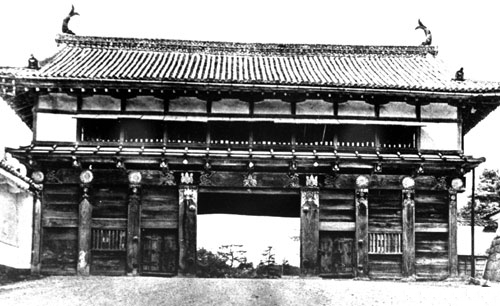
    The former Ōtemon gate of Sendai Castle photographed in July 1938
    Sendai Castle’s former Ōtemon, July 1938. A historic view of the gate, not a photograph of an excavated onigawara. Mainichi Shimbun; public domain, via Wikimedia Commons.

    Excavated evidence: gold and roof ornaments

    Sendai City records 56 gilded tile pieces, including a chrysanthemum onigawara, and more than 200 shachi-tile fragments from the main enclosure. These are different kinds of roof ornament. The city associates onigawara and shachi with decoration and fire-averting symbolism. It also cautions that the purpose of gilded tiles at early-Edo Sendai Castle requires further research.

    A gate recovered through archaeology

    The city’s report on investigations in 2023–2024 records an onigawara from the Ōtemon area. It also describes tiles reddened by the 1945 air raid. Such finds connect architectural history with the physical traces of the gate’s destruction.

    Putting the fragments in context

    A municipal excavation leaflet describes Ōtemon as a special entrance used for the lord and ceremonial occasions. The gate measured approximately 12.5 metres high and 20 metres wide. The leaflet identifies the onigawara discovered in 2024 as evidence for understanding the roof before the war.

    Sendai Castle stone walls, 25 March 2007. A contextual photograph of the castle ruins.
    Sendai Castle stone walls, 25 March 2007. A contextual photograph of the castle ruins. Photo: Yamaguchi Yoshiaki, CC BY-SA 2.0, via Wikimedia Commons.

    How to read a protective ornament

    The historical belief that a roof ornament could avert fire should be understood as symbolism. Archaeological objects can document where ornament was used and what survived; they cannot demonstrate supernatural protection. Likewise, a gold surface alone does not settle the political meaning of a building. Here, the most revealing story lies in the relationship between the excavated fragments, the written interpretation and the surviving photograph.

    Sources

    JAPAN ESSENCE Editorial Team

    Stories of Japan’s legends, myths, festivals and cultural heritage.